
Kane Creek Preservation and Development Project at Kings Bottom
February 12, 2024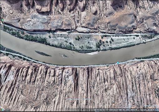
More about the photo above: Kings Bottom is an attachment bar, which are created by large eddies during large flood events; expansion bar is actually the better word. When the next large flood arrives, there will be slope failures, and/or infrastructure will be crushed by all the driftwood and woody debris entrained within the flood flow and the recirculating eddy. When the flood recedes, the entire bottom will be replaced by an entirely new and different attachment bar, which may be larger, smaller, or become an island, or dissappear altogether.
In other words, in a river corridor, terminal eviction eventually happens to every property owner, including the Bureau of Reclamation, the ultimate dam builder.
It is not wise to dismiss the natural movements and pulses of Nature's water cycle. Consider that the Colorado River has already eroded half the total volume of the Colorado Plateau's massive rock formations that are either volcanic, metamorphic, or sedimentary (marine and continental).
Consider too, that the geologic history of the Colorado River is a classic "fill and spill" basin. An incredibly vibrant river system that, in geologic time, just recently reached the ocean. This river is still young, in that it has yet to accomplish filling the last structural depression with detritus from the Colorado Plateau and the Rocky Mountains. This depression is below sea level and known as the Salton Sink in southern California and northern Mexico.
- Cenozoic Geology of the Colorado Plateau. Charles Butler Hunt.
- Note: this professional paper was written in 1956. It is still the most referenced geology paper ever written about the Colorado Plateau.
_____________________________________________
YES! Canyonlands Watershed Council is a charitable organization.
- PayPal - HERE
- Venmo - HERE
- Our EIN is: 87-0637713
- Friends of the Abajos doing business as Canyonlands Watershed Council.
_____________________________________________
DEVELOPERS - CONTACT INFORMATION
Kane Creek Preservation and Development, LLC
- eMail: info@kanecreekmoab.com
- Partners: Craig Weston, Tom Gottlieb & Trent Arnold
- Website: does not yet exist
- Civil Engineer: Jeff Pillus; jeffp@setengineering.com
- Attorney: J. Craig Smith; jcsmith@shutah.law
- Securities and Exchange Commission Document for Kane Creek LLC
- Request To Grand County For Sanitary Sewer Service
- Application for sewer service by Kane Spring Improvement District
KANE SPRING IMPROVEMENT DISTRICT BOARD MEETINGS
- Contact info: kanespringsimprovementdistrict@gmail.com
- Website
- Application for sewer service by Kane Spring Improvement District
- June 14, 2023 - Agenda of first meeting
- June 14, 2023 - Audio recording of first meeting
- September 05, 2023 - Minutes
- February 23, 2024 - Minutes
- 1997 to 2023 - Satellite imagery above Kings Bottom. Google Earth.
- January 2024 - Mechanical excavation on the perched benches layered with Pleistocene river gravels above Kings Botttom.
- Note: The total volume of excavated fill material is estimated to be 827,000 cubic yards (51,688 truck loads).
PERMIT FOR SEWAGE TREATMENT FACILITY
PUBLIC ANNOUNCEMENT: There is a public meeting on August 3, 2023 at the Grand Center that begins at 6pm. This hearing is about a permit application to construct an independent, on site sewage treatment plant at King's Bottom along Kane Creek Road and the Colorado River.
The developer is Kane Creek Preservation and Development, LLC (KCPD)
- Application for sewer service by Kane Spring Improvement District
- DWQ's Website for permit application for KCPD
- Approval of discharge permit for KCPD's minor municipal sewage treatment plant. DWQ.
The extented comment period closes August 4th, 2023
AGENDA: From Utah Department of Water Quality (DWQ); the agency contact person is Jeff Studenka
- Open House for Discharge Permit Application for Utah Pollution Discharge Elimination System (UPDES) (sewage processing facility) for Kane Creek Development and Preservation, LLC.
- Informational session begins at 6:00 pm
- Hearing from to 6:30 pm to 8:00 pm on August 3, 2023
- Grand Center, Main Hall
- 182 N 500 W Moab, UT 84532
- Public Presentation by DWQ of Jeff Studenka at Moab on August 3, 2023.
- Recording of Public Hearing. Note: This recording was not edited and the proceedings do not begin until minute 53.
- Application for sewer service through Kane Spring Improvement District
- Public Notice nd Public Hearing for KCPD sewage treatment plant. DWQ.
- Fact Sheet for sewage treatment plant. DWQ.
- Feasibility study for water supply and wastewater treatment. Anderson Engineering. (includes brief development plans)
- Spreadsheets of data and notes for sewage treatment plant. xlsx file.
- Wasteload Analysis. Shope.
- Kane Creek Road and King's Bottom are below the 100-year flood zone (156,440 cubic feet per second. See: Year 2014 calibration table in the Flood Hazard Section, above).
- King's Bottom is an attachment bar, which are created by large eddies during large flood events. When the next large flood arrives, there will be slope failures at King's Bottom, and/or infrastructure will be crushed by all the driftwood and woody debris entrained within the flood flow and the recirculating eddy. When the flood recedes, the entire bottom will be replaced by an entirely new and different attachment bar, which may be larger, smaller, or become an island, or dissappear altogether.
- This is a preliminary discussion based on public information that is limited, or withheld. At some point a request for information will be provided via GRAMA Request (See Administrative Documents section above).
- In the floodplain (below the 100-year level) of the Colorado River, roads and residential homes will be constructed.
- The last 100-year flood occurred in 1862; that event was an atmospheric river from the Pacific Ocean that lasted 43-days. A near 100-year flood occurred in 1884. Several large floods occurred in a pluvial between 1905 to 1921. Flood frequency and flood magnitude is expected to increase because our warming atmosphere can hold more water vapor.
- The development will require flood insurance and the premiums will be high. This insurance will be federal flood insurance (FEMA).
- Before housing can be developed, it is obvious that a traffic plan to handle increased traffic will be necessary, for vehicles hauling heavy payloads, and for first responder vehicles.
- It is obvious that the utility corridor will have to be improved, which includes the installation of fire hydrants and a storage tank for the water.
- There will be amenities in the floodplain of the Colorado River. We assume this include eateries, hotels, rentals, and other commercial enterprises.
ANNOUNCEMENT: October 11, 2023 - FINAL Decision of Department of Water Quality regarding complain by citizens and the subsequent public hearing on June 14th.
SUMMARY - What was approved is the sewage treatmant facility of the proposed development. It has been determined that "Permit coverage under the UPDES Construction General Storm Water Permit is required, however, for any construction at the faicility which disturbs an acre or more or is part of a common plan of development or sale that is an acre or greater."
Further information regarding storm water permit requirements can be found at http://stormwater.utah.gov.
PUBLIC HEARING DOCUMENTS
- Decision Reference Email. DWQ.
- Public Comments Responsiveness Summary. DWQ.
- Moab Public Hearing Comments Regarding Kane Creek UPDES 2023 Permit. DWQ.
- Kane Creek Preservation And Development UPDES Permit. DWQ.
APPEAL PROCESS
- The procedures for appealing a permit decision can be found under Utah Code § 19-1-301.5 and Utah Admin. Code R305-7-104(5) and R305-7-203.
Construction approved by Utah Department of Environmental Quality, which issued a Utah Pollution Discharge Elimination System (UPDES) Permit to Kane Creek Preservation and Development, LLC (KCPD) will begin on December 4, 2023.
Citizens requested a public presentation about this permit, which was granted, and as follows
ANNOUNCEMENT from Utah Department of Water Quality.
- Public Meeting
- Monday, November 27, 2023
- Virtual Meeting Time: 6:00-7:00 PM
- Staff presentation: 6:00-6:20 PM
- Questions: 6:20-7:00 PM
Zoom credentials:
- https://utah-gov.zoom.us/j/82526987466?pwd=Zy9WWUFXdXlTR0JXMTR2NjlFVTBxZz09#successHEARING
- ID: 825 2698 7466
- Passcode: gOfR^Y4t
- Permit: UPDES Construction General Permit, Permit Number UTRC0000
- Agency: Utah Department of Environmental Quality, Division of Water Quality
In compliance with the Americans with Disabilities Act, individuals with special needs (including auxiliary communicative aids and services) should contact the Utah State Accessibility website at https://www.utah.gov/accessibility.html
Talk about this article...