
Lithium corporations pursue limited water supplies in the Colorado River Basin
March 08, 2024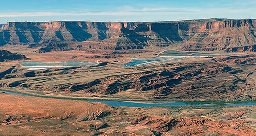
- Click here to read this story by Anastasia Hufham for the Salt Lake Tribune.
- Click here to review the plaintiffs complaint.
- Click here to review the administrative record for this mining project by Blackstone Minerals and Anson Resources.
Presentation about proposed lithium extraction at City of Green River, Utah
- 2024, August - Best practices for recycling and reinjecting lithium brine. Zelandez.
- 2024, August - Direct Lithium Extraction: A report exploring the various technologies used for direct lithium extraction (DLE). International Lithium Association & Rockwel Automation.
- 2024, March - Determining the Product Carbon Footprint of Lithium Products. Guidance for calculating a product carbon footprint (PCF) of key lithium intermediates and battery-grade lithium carbonate and hydroxide specialty chemicalsproduced from brine or rock minerals. International Lithium Association.
- 2024 - Lithium and water hydrosocial impacts across the life cycle of energy storage. Blair, et al.
- 2023 - Environmental impact of Direct Lithium Extraction from brines. Vera et al.
__________________________________________________
- November 9, 2024 -Judge extends lithium drilling freeze, a major win for the Hualapai Tribe. Shondiin Silversmith for Utah News Dispatch.
- October 9, 2024 - More lithium projects approved in Utah's Redrock Country: Exploring for the mineral, which is vital in rechargeable batteries uses a lot of water. By Anastasia Hufham for Salt Lake Tribune.
- October 1, 2024 - BLM approvals put famed southern Utah redrock landscapes in the crosshairs of industrial development. Press release by Southern Utah Wilderness Alliance.
- August 21, 2024 - Mandrake Resources inks supply agreementand gets free pilot plant. By New Investors.
- July 25, 2024 - Boiling Point: The Salton Sea lithium rush. By Melody Petersen for LA Times.
- July 18, 2024 - Lithium critical to the energy transition is coming at the expense of water. By Wyatt Myskow for Inside Climate News.
- July 15, 2024 - As a Nevada community fights a llthium mine a rare fish and its haven could be an ace in the hole. By Wyatt Myskow for Inside Climate News.
- June 8, 2024 - Water rights debate on the Green River may stop projec. By Anastasia Hufham for Salt Lake Tribune.
- May 29, 2024 - Company says lithium projectIs as green as possible but evironmental groups not convinced. By Kyle Dunphey for Utah News Dispatch.
- April 2, 2024; OpEd - More on the Green River llithium plant. By Sarah Fields for Moab Times-Independent.
- March 29, 2024 - Why the "white gold" rush won't save the planet. Joshua Frank for Counter Punch.
- March 26, 2024 - Lithium company addresses residents after March 8 water surge. By Sophia Fisher for Moab Times-Independent.
- March 24, 2024 - Mining Companies Say They Have a Better Way to Get Underground Lithium. but Skepticism Remains. By Wyatt Myskow for Inside Climate News.
- March 15, 2024 - As water erupts from lithium exploration site, so do fears over project. By Jennifer Yachin & Hannah Northey for GreenWire.
- March 13, 2024 -Lithium well blowout didn't breach the Green River, state says. By SophiaFisher for Moab Times-Independent.
- March 12 - A1 Lithium announces water use estimates. Sophia Fisher for Moab Times-Independent.
- March 9, 2024 - Skepticism at lithium hearing. The Green River Observer.
- February 15, 2024 - Bumpy road for EVs and climate goals. By Russ Mitchell for Los Angeles Times.
- February 8, 2024: Special Feature - In rural Utah, concern over efforts to use Colorado River water to extract lithium. By Suman Naishadham and Brittany Peterson for The Associated Press.
- January 26, 2024 - Howard Center investigation into lithium mines gains national media exposure. Cronkite School at ASU.
- January 26, 2024 - Mining Monitor, Moab's Kings Bottom Development and Sun Zia lawsuit. By Jonathan Thompson for The Land Desk.
- Lithium Miners want mega amounts of Utah water in the Colorado River Basin. By Leia Larson for Salt Lake Tribune.
- Lithium in Paradox: aridity could nip a new Utah mining rush in the bud. Jonathan Thompson for the Land Desk.
- Will Green River be home to a new lithium mine to help US go 'green'. Amy Joi O'Donoghue for Deseret News.
__________________________________________________________
- May 21, 2023 - Letter to State Engineer: Request for Reconsideration on Approval of Application to Appropriate Water. Clyde, Snow and Sessions on behalf of Protestants. This request was granted. See: Water Right # 92-695
- Close of Comments: June 24, 2024
- July 24, 2024 - Public comment letter from Living Rivers & Great Basin Water Network
- Contact (Email): Porter Henze
- Public Notice
- Draft Permit
- Draft FSSOB
- Public Hearing: None
- Type: Underground Injection Control
- Visit the archive page
Aquifer Spent Brine Recovery Well (Class 5 Injection Well)
Public comments are due December 14, 2023.
Division of Water Quality
PO Box 144870
Salt Lake City, UT 84114-4870
eMail: wqcomments@utah.gov
- Public comment Letter to DWQ: Living Rivers and Great Basin Water Network.
- Public Comment Letter to DWQ: Gayna Salinas
The Colorado and Green rivers have nothing left to give. This river basin's transformation from abundance to exhaustion occurred between the Reclamation Act of 1902 and the Shortage Guidelines of 2003.
1. Anson Resources (Australia)
- Home page - https://www.ansonresources.com
- Investor Center - https://www.ansonresources.com/investor-centre/
Subsidiaries of Anson Resources
- Blackstone Minerals (Las Vegas, NV)
- A1 Lithium (Las Vegas, NV)
Chronology of Anson Resources
- 2016 - begins operations in Grand County, Utah (near Dead Horse Point))
- 2021 - begins operations in Green River City, Utah
- 2023 - Annual Report
- Listcorp: Investor Presentation (archived)
- Bruce Richardson - Executive Chairman and CEO
- Peter (Greg) Knox - Director (geologist).
- Michael van Uffelan - Director (secretary).
- Operations are in San Juan County, Utah; Lisbon Valley & Dry Valley.
- Home page - https://www.mandrakeresources.com.au (archived)
- May 22, 2023 - Wells secured for re-entry of lithium sampling at Utah lithium Project. Mandrake Resources.
- May 16, 2023 - Lisbon Valley mining land rush continues. The Land Desk by Jonathan Thompson.
- May 1, 2023 - Mandrake Resources stakes almost 90,000 acres at Utah lithium project.
3. Sunresin (China) and introducing a new technology called Direct Lithium Extraction (DLE)
- Sunresin's corporate website
- This technology is currently proposed for operations by Anson Resources at Green River City, Utah
###
Subsidiary of LG Chem (South Korea)
###
Lisbon Valley, San Juan County Utah
- Corporate website
- November 22, 2023 - Corporate Update
Lithium extraction from the Paradox Formation
Green River City; Emery and Grand Counties, Utah
Utah Division of Water Rights
- Water Right # 92-695 - Current water right
- Water Right # 92-169
- Water Right # 92-40
- Water Right # 92-35
- Water Right # 92-698 - Temporary (one-year) application to Appropriate.
- Water Right # 92-695 - Underground Water Well (exisiting)
- Water Right # 95-434 - Admin record for water right transfers from Wayne County to Emery County & News by Patty Henetz for Salt Lake Tribune.
Aquifer Spent Brine Recovery Well (Class 5 Injection Well)
Public comments are due December 14, 2023.
Division of Water Quality
PO Box 144870
Salt Lake City, UT 84114-4870
eMail: wqcomments@utah.gov
- Public comment Letter to DWQ: Living Rivers and Great Basin Water Network.
- Public Comment Letter to DWQ: Gayna Salinas
- What: DOGM regulated exploratory and brine sample well: Casing is 24" in diameter at top, 7.625" at the bottom. Max depth Approx 10,800`.
- Location: Green River City, 1600 S 1015 E Green River, UT 84525.
- Purpose: Assay for lithium content and extraction of lithium for onsite sample/demonstration purposes.
- Explanatory: This temporary application is for the purposes of assaying deep ground brine for lithium, mineral content and other constituents to determine the viability of developing mineral extraction. Also to process brine through a small-scale temporary sample demonstration and pilot plant that is located next to the well site (Bosydaba #1) and to demonstrate the suitability of the brine for extraction and lithium production.
- Disposal: After extracting lithium from the brine, the unaltered spent brine is returned and disposed of at DEQ disposal facility at Danish Flat Section 8, T20S R24E SLMB.
DWQ is holding a public hearing to solicit further comments on the Draft Permit.
- The informational website is located HERE.
- Location: Green River City Hall, 460 E Main St, Green River, Utah, 84525
- Date: February 21, 2024
- Time: DWQ Informational session begins at 6:00 pm
- Time: 6:30 pm to 7:30 pm
- Comments will be accepted until February 23, 2024
- eMail: wqcomments@utah.gov
- Contact: Porter Henze at 385-566-7799
- Internet access is not available (unless previously arranged).
Division of Water Quality
Second Public Notice of Permit UTU-19-F4-8F9143D
Underground Injection Control Class V Well Permit
31 using extraction wells. Brines will be processed using a lithium carbonate and lithium hydroxide production plant utilizing direct extraction. The spent brine that is depleted of lithium will be
pumped into the injection wells under pressure into the Paradox formation between clastic zone 7 and 19, or about 6,040 to 6,445 feet below ground surface.
- May 1, 2024 - Letter from citizens about Blackstone Minerals lithium operations in the designated radiation zone of the Uranium Mill Legacy Site at Green River in Emery and Grand Counties.
- May 31, 2024 - Response to citizens. UDEQ & RCB
YES! Canyonlands Watershed Council is a charitable organization.
______________________________________________- Location: Near the Colorado River in the vicinity Dead Horse Point and Big Flat and the Intrepid Potash Facility
- Note: This proposed lithium project is presently in limbo.
- Admin record for A1 Lithium: #01-1233 (A83900)
- A1 Lithium, Inc. submitted a revised Plan of Operations to conduct Mineral Exploration on its unpatented placer claims located approximately 9 miles west of Moab, Utah (Big Flat) by reentering two abandoned well bores, Sunburst #1 and Mineral Canyon Federal #1-3, to test brine solutions for lithium and bromine.
- An exceptional report by EarthWorks will provide more information HERE
- This report examines a new and emerging technology called Direct Lithium Extraction (DLE).
- REPORT: Environmental Justice In California's Lithium Valley. Earthworks.
- We could not confirm that Anson Resources received an exemption from a air quality permit.
- We could not confirm that a large mining permit is required.
____________________________________________
ADDITIONAL PUBLIC INFORMATION ABOUT LITHIUM EXTRACTION
____________________________________________
Consumptive water use for proposed lithium projects
- Mandrake at Dry Valley: Unknown; potentially 150 groundwater wells?
- A1 Lithium at Big Flat: 13,764 acre-feet per year (Colorado River)
- Blackstone at City of Green River: 13,764 acre-feet per year (Green River)
- Anson Resources at/near Town of Hanksville: Unknown; Fremont River water transfers from Wayne County to Grand County?
- Note: There is only one DLE operation in the United States and located at Imperial County, California and in the the Salton Through (a structural depression). There is a consumptive use from the Colorado River for this project.
- REPORT: Environmental Justice In California's Lithium Valley. Earthworks.
- Direct Lithium Extraction (DLE). Beads of resin that attract lithium carbonate; no evaporation ponds. A technology developed in China with proprietary rights.
- Brine in solution (liquid) is naturally delivered to the surface by the pressure of 9,000 feet of overburden. Anson claims this pressure is sustainable for the project's lifetime (reference), but this statement is a double negative.
- A conceptual exploration target of between 2.1 and 2.56 billion tonnes of brine, grading between 108 and 200 parts per million (ppm) lithium and between 2,000 and 3,000 ppm bromine (reference).
- For the purpose of providing a constrast to Anson's lithium target, the concentration of the potassium target in the Paradox Formation can be as high as 42,000 parts per million.
- The return on investment for these two resources is nearly equivalent. We think protecting the water resources of the Colorado River Basin is what is truly priceless.
- Report: Environmental Justice In California's Lithium Valley. Earthworks.
- Report: Identifying Potential Hydrologic Impacts of Lithium Extraction in Nevada. Saftner, 2023; DRI for TNC.
Located near Dead Horse Park in Grand County and Canyonlands National Park in San Juan County, Utah.
- Website: Paradox Lithium Project
- Low interest loans from US Department of Energy
- Extraction goal: 10,000 tons per year of lithium carbonate
- 2021 - Exploration Plans. Millcreek Mining.
Bureau of Land Management Administrative Record
- 2022 - Draft EA for A1 Lithium. BLM.
- 2022 - EA for A1 Lithium. BLM.
- 2022 - Visual Assessment. BLM.
- 2023 - Updated Mineral Exploration Project. BLM.
- 2023 - Comment Letter to BLM. Living Rivers.
- 2024 - Final EA & FONSI (Finding of No Significant Impact). BLM.
Paradox Project by Blackstone; subsidiary of Anson Resources
Green River Project: City of Green River in Emery County Utah
- Minutes of October 25, 2023. City Council of Green River.
- Website of Green River Project; (archived)
- News October 2023 - Anson Confirms Green River Plant Location. Esmarie Iannucci for Mining Weekly Austrailia.
- 40-year Plan. Wayne County Water Conservancy District.
- Note: The 40-year plan does not mention litium extraction. The water conservancy district of Wayne County does not have a public web page about their activities.
- November, 2023 - Anson Resources Project. Roerink for GBWN.
Agency
- Bureau of Reclamation
- Note: Reclamation believes an environmental assessement for a federal water contract is required.
- Homepage: https://oilgas.utah.gov
- Data Explorer: https://dataexplorer.ogm.utah.gov/
- APIs in the Long Canyon area: Lithium well 43 019 50096; Lithium well 43 019 15925; Lithium well 43 019 50095; Lithiuk well 43 019 30357; Lithium well 43 019 31319; Lithium well 43 019 30810;
Subcontractors
- Mike Swenson - attorney from Emery County in Orangeville, Utah.
Geology
- 1965 - Subsurface Brines Moab Region Utah. Special Studies 13; UGS.
- 2009 - Hydrogeochemical characterization of Leaking Carbon Dioxide Charged Fault Zones in East Central Utah with Implications for Geologic Carbon Storage. Heath & Lachmar et al.
- 2009 - Reservoir Characteristics of Clastic Cycle Sequences in the Paradox Formation of the Hermosa Group in Utah. Trudgill.
- 2011 - Well Database of Salt Cycles of the Parodox Basin in Utah. Massoth.
- 2011 - Green Energy Project Grand County
- 2019 - Lithium Recovery From Oil And Gas Produced Water
- 2022 - Paradox Basin Lithium and Brine Project.
Areas near City of Moab
- There will be water diversions in Grand County.
- There are well pads and they are small.
- We have drilled near Moab and determined lithium extraction will be successful.
- Note: We could not verify this statement; they may be referring to drill logs from other company operations.
- The lithium reserve may by one to three million metric tons. Currently the price for lithium carbonate is between $20,000 to 30,000 per ton. The low end is $7,000 and high end is $50,000.
- We intend to use this lithium resource in the USA. Most lithium is exported from Argentina and China.
- We want to work in Green River for railway and interstate transportation and for a work force and to be near a flowing river.
- We hope to discover a viable similar to the Moab location. There are brine layers in the vicinity and we intend to drill some exploratory wells.
- Water diversions are required and we have a lease agreement from Green River Corporation.
- There will be no return flows back to the Green River. They will be injected into the Paradox Formation.
- There are well pads and they are small.
- We are not piping brine from Moab to Green River. BLM won’t allow that.
- Footprint will be about 18 acres. There will be a warehouse-like building. It will be in city limits and not in Grand County.
- We are working with the utilities. We are not that far along.
- 300 construction jobs for two years. 50 to 70 employees after that. Don’t know what the salaries will be.
- "This is going to happen whether you like it or not. Otherwise you’ll have China in your background."
- Point of diversion on our property. We have a change application in process.
- We intend to apply for an air quality permit; we understand we will get an exemption (di minimus)
- Don’t have a chemical list quite yet. Hydrochloric acid will be necessary. Don’t know how much.
- We can apply for government energy subsidies.
- We havea website with limited information.
- We have expertise in Boca Raton, Florida.
- Our lithium meets or exceeds the standards of Tesla, Inc.
- We intend to provide scholarships to school children in Emery County.
Narrative about the Paradox Basin
Sub-surface brines in the Paradox Formation of eastern Utah can carry trace amounts of lithium carbonate (an inorganic compound of lithium, carbon and oxygen) at depths about 9,000 feet. Another desireable trace mineral includes bromine. Deposits here are below sea level, under extreme pressures, and at temperatures higher than a hot tub.
The Paradox Basin region includes the counties of the "four corner states:" Arizona, New Mexico, Colorado and Utah. Grand County, Utah has the most crustal deformation, which is caused by the dissolution of the underlying salt formations, due to hosting the incised canyons of the Colorado River and its close proximity to the La Sal Mountains, which condenses a significant amount of precipitation from the atmosphere (meteoric water) and dispersed as groundwater and as spring fed surface water.
The Paradox Formation consists of diverse layers of gypsum, anhydrite, and salt, interbedded with shale, sandstone, and limestone. There are geologic traps that contain reserves of petroleum, natural gas, carbon dioxide, and helium.
The Paradox Formation was formed in the Pennsylvania Period near stuctural depressions along the coast of the ancestral Rocky Mountains and the ancestral Pacific Ocean. Very similar to structural depressions such as the Salton Through and Death Valley in California (Basin and Range Province).
Sea level fluctuations were wildly aggressive during that time period. The basins filled with seawater and then evaporated away in at least 33 individual cycles, or until these basins were completely filled with deposits of sea water evaporates.
And then they were buried at depth by subsequent formations (overburden) during the Mesozoic and Cenozoic Eras, which are now being incised and dessicated by the aggressive erosive power of the Colorado River, which is even piercing through the Paradox Formation in Moab-Spanish Valley, Utah, and Cataract Canyon in Canyonlands National Park. This includes a tributary, the Dolores River, adjacent to the eastern slopes of the La Sal Mountains at Paradox Valley, Colorado.
Drilling pads are required to mechanically install steel well casings into a targeted layer of brine. Anson consultants say that the brine layers they are targeting are already saturated and that freshwater injection is not required. (Reference)
What is different about Anson Resource's proposed and untested technology for mineral extraction in the Paradox Basin, is that evaporation ponds are not necessary to remove the processing liquids. They intend to use beads of resin that attract the lithium ions that this process crystalizes. This technology was developed in China and requires a licensing agreement for users such as Anson Resources.
The processing water is then returned to the subsurface with injection wells, which requires the drilling of more well cases and utilizing high pressure pumps, which also is not a new technology, but requires a 10-year operating permit from the Environmental Protection Agency (EPA).
For instance, the Bureau of Reclamation's operating permit in the western Colorado intercepts brine water that seeps into the Dolores River. Reclamation then injects the captured brine at depths of 16,000 feet (the deepest well casings in the world). This facility is located at Paradox Valley, Colorado, which is the name sake (type locality) for the Paradox Formation.
This practice by Reclamation has been recently modified to smaller injection volumes to avoid the hazards of earthquakes. Another public concern is pressurized brine can cause fractures in crustal rocks (hydro-fracking) and this leakage under pressure could contaminate nearby layers of fresh groundwater.
###
The serious issues about drilling for rare metals in the Paradox Basin to make car batteries include installing well casings that wobble, warp, buckle and break in geologic formations that resemble toothpaste, rather than durable bedrock.
Also how to avoid accidentally venting hydrogen sulfide gas, natural gas, nitrogen gas, and helium gas into the atmosphere, at the work place, or into the neighborhood.
Not to forget how to avoid mobilizing formation water at depths between 8 and 10 thousand feet that is very stinky and toxic (hydrogen sulfide).
We also think it is important to mention that lithium batteries will not power these operations. What will power and construct the intense extractive operations of Anson Resources is fossil fuels.
____________________________________________________
Drilling issues near the Green River in Grand County, Utah.
- Abstract: Office of Scientific and Technical Information. DOE.
- Abstract: Four Corners Geological Society
"The Salt Wash field is located 15 miles southeast of Green River, Utah, in the Paradox fold and fault belt. The field was discovered in 1961 and has produced over 1.3 million bbl of oil and 11.6 billion ft of gas from the Mississippian Leadville LImestone. The average surface elevation is 4,389 ft above sea level, and the depth to the top of the oil production is form 8,500 to 8,914 ft. Salt Wash field is an anticline with over 200 ft of closure on top of the Leadville. The producing zone is in the lower Leadville with intercrystalline and vuggy porosity developed in limestone and crystalline dolomitic limestone. The produced oil is a 50 to 53 API gravity crude with a 40 degrees F pour point. The gas, a mixture of two sources, is predominately nitrogen with some hydrocarbons (>10%) and smaller amounts of carbon dioxide and helium. All of the original wells suffered casing collapse in the overlying Paradox section resulting in their premature abandonment.
Additional undeveloped Leadville reserves may still be present. There may also be undiscovered reserves in the stratigraphically higher Cane Creek shale of the Pennsylvanian Paradox Formation in the Salt Wash field. The field is roughly 12 mi northwest of the Kane Springs unit where Columbia Gas has been completing horizontally drilled wells in the Cane Creek. The State 1-16A in Salt Wash field recovered 600 ft of 52 API gravity crude and no water from a drill-stem test of the Cane Creek. The State 1-16A well in Salt Wash field recovered 600 ft of 52 API gravity crude and no water from a drill-stem test of the Cane Creek. Reverse faulting and recumbent folding combined with structural closure increases the potential for fracture development in the Cane Creek at Salt Wash field."
END
###
###
Talk about this article...