Floods
YES! Canyonlands Watershed Council is a charitable organization.
You can donate to CWC using our PayPal Console HERE
______________________________________________
FLOODS IN GRAND COUNTY, MOAB CITY & COLORADO RIVER BASIN
Visit: On The Colorado for a more detailed list of flood related publications.
- 1929 - Floods of the Upper Colorado. Follensbee.
UMTRA STEERING COMMITTEE MEETING (January 24, 2017)
- Handout 1: Summary by John Weisheit
- Handout 2: Photo of slackwater deposits with legend (line art)
- Handout 3: Photo of slack water deposits with legend of flow in cubic meters per second
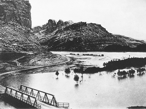
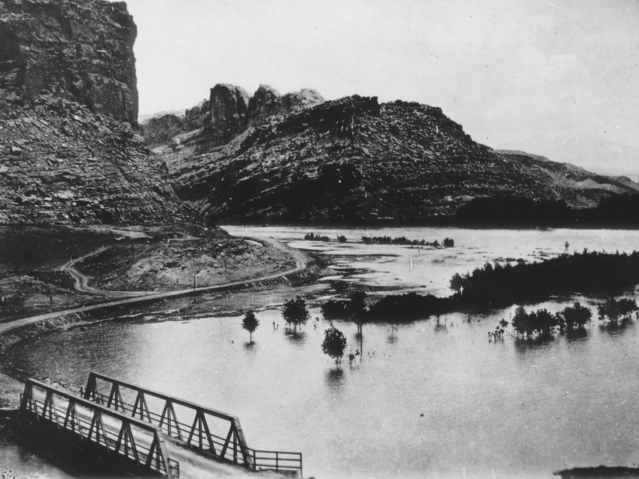
- Handout 4: 1921 - Photo of Colorado River in flood near Moab
- Handout 5: 2005 - Moab's Colorado River floodplain: extent of 300,000 cfs flood event. John Dohrenwend.
- Recommended reading: 2006- A technical report towards reclaiming uranium mill tailings along the Colorado River in Grand County, Utah.
- Recommended reading: 2014 - 2000 Year Record of Magnitude and Frequencies of Largest Upper Colorado River Floods at Moab, Utah. Greenbaum et al.
- Recommended reading: 2014 - Paleoflood Hydrology of Stillwater Canyon, Green River and Cataract Canyon, Colorado River (preliminary results). Greenbaum, et al.
DOCUMENTS
- 1944 - Water Supply Paper 918. USGS; Dickinson.
- 1948 - Floods in Colorado. USGS; Follansbee.
- 1946 - Cloudburst floods in Utah. Woolley. US Geological Survey.
- 1962 - Floods in Utah: Magnitude and Frequency. Berwick.
- 1976 - Narrative of flooding in Moab. McConkie-Tanner.
- 2002 - Discussion: the flood of 1884 and the flood of 1983. Swain; Bureau of Reclamation.
- 2003 - Investigation of the Hydrogeologic Connection between the Moab Mill Tailings and the Matheson Wetland Preserve. Philip Gardner and D. Kip Solomon.
- 2004 - Initial-Phase Investigation of Multi-Dimensional Streamflow Simulations in the Colorado River, Moab Valley, Grand County, Utah. Terry A. Kenney, US Geological Survey.
- 2005 - Special newspaper supplement about the Moab Mill Project. Moab Times-Independent.
- 2006 - Moab Mill Site special presentation at the Moab Information Center. John C. Dohrenwend.
- 2006- A technical report towards reclaiming uranium mill tailings along the Colorado River in Grand County, Utah.
- 2010 - Flooding in the Dolores River Basin, Colorado and Utah: Insights from Paleofloods, Geochronology and Hydroclimatic Analysis. Cline.
- 2014 - 2000 Year Record of Magnitude and Frequencies of Largest Upper Colorado River Floods at Moab, Utah. Greenbaum et al.
- 2014 - Paleoflood Hydrology of Stillwater Canyon, Green River and Cataract Canyon, Colorado River (preliminary results). Greenbaum, et al.
- Grand County UMTRA Project (uranium mill tailings removal).
GRAPHICS
- 1921 - Photo of Colorado River in flood near Moab
- 2005 - Moab's Colorado River floodplain: minimum extent of gravel bars. John Dohrenwend.
- 2005 - Moab's Colorado River floodplain: extent of 300,000 cfs flood event. John Dohrenwend.
- Photo of slackwater deposits with legend (line art)
- Photo of slack water deposits with legend of flow in cubic meters per second
BRIEF ANALYSIS:
PALEOFLOOD RECORD OF COLORADO RIVER ABOVE MOAB
2014 - 2000 Year Record of Magnitude and Frequencies of Largest Upper Colorado River Floods at Moab, Utah. Greenbaum et al.
The purpose of the study, performed by University of Arizona (Tucson) under the direction of Victor Baker, John Dohrenwend and Noam Greenbaum, was to provide rigorous data to stakeholders and decision-makers to help ensure the removal of Moab’s uranium waste pile from the floodplain of the Colorado River, which is indeed happening. So far, 50% of the pile has been removed and taken by railroad to a burial site 30 miles north of town at a location called Crescent Junction adjacent to the I-70 corridor. The funding for this paleoflood project was provided by The Citizens' Monitoring and Technical Assistance Fund.
After the report was published, paleoflood research has continued in the upper basin of the Colorado River. For example, in 2010, sites along the Dolores River were located and sampled. In 2010 and 2012, sites were located and sampled in Stillwater Canyon on the lower Green River, and in Cataract Canyon below the confluence of the Green and Colorado rivers. Work in the near future will occur in Grand Canyon.
Highlights of this report include:
- River section: Upper Colorado River (above the Green River confluence and below the Dolores River, the last major tributary)
- Site location: 10.5 miles above the Moab Bridge
- Time frame: The last 2,140 years (+/- 220 years)
- Number of floods: 44
- Range of floods in cfs: 60,036 to 349,616
- 34 - 40 floods: exceeded the magnitude of the USGS 100-year flood determination
- 20 - 25 floods: exceeded the magnitude of the USGS 500-year flood determination
- 5 floods: exceeded a peak discharge of 282,000 cfs
- Largest floods: two were slightly over 349,000 cfs
- 100-year flood: peak discharge ranging from 156,440 to 179,050 cfs
- 500-year flood: peak discharge ranging from 224,780 to 265,570 cfs
- 1000-year flood: peak discharge ranging from 256,740 to 310,770 cfs
ADDITIONAL INFORMATION
- Updated Report (2006b)
- Moab Mill Project Cover Letter
- Moab Mill Project Brochure
- Moab Mill Project Poster
- 1994 - Paleoflood study of Colorado River at Grand Canyon. O'Conner et al.
- Click here to read Dam Failure Inundation Study by the Bureau of Reclamation (1998).
- Click here to learn more about the flood of 1884 and the flood of 1983
/farcountry